Support our educational content for free when you purchase through links on our site. Learn more
21 Caretera Austral Road Trip Tips 🚗

The best Caretera Austral road trip tips are simple: allow at least three weeks, rent a high-clearance vehicle with a full-size spare, and leave several days unplanned for ferries, weather, and the odd Patagonian surprise.
This legendary Ruta 7 journey stretches through Chilean Patagonia from Puerto Mont toward Villa O’Higgins, linking fjords, rainforest, glaciers, turquoise rivers, and mountain passes. It is breathtaking, remote, and occasionally capable of turning a “quick drive” into an all-day adventure.
We once watched a perfectly clear morning dissolve into rain, wind, and low cloud before lunchtime. The road did not care about our schedule, but a flexible plan, offline maps, extra food, and a warm waterproof layer saved the day. That is the secret: prepare seriously, then travel lightly enough to change course.
From ferry reservations and fuel stops to gravel-road driving, camping gear, border crossings, and the best detours, these practical tips will help you enjoy the route without treating Patagonia like a race track.
Key Takeaways
- Allow 21 days minimum for the main route; four to five weeks gives you time for hikes, detours, and weather delays.
- Choose a high-clearance SUV, pickup, or 4WD with a full-size spare tire and permission to drive on gravel roads.
- Reserve key ferries early, especially the Hornopirén–Caleta Gonzalo connection during summer.
- Refuel whenever possible and carry extra water, food, cash, and offline maps.
- Expect changing weather, potholes, construction, limited cell service, and slower-than-expected driving days.
- Prioritize Pumalín, Futaleufú, Queulat, Cerro Castillo, Marble Caves, Exploradores Glacier, Caleta Tortel, and Parque Patagonia.
- Build in two to four buffer days so one delayed ferry or storm does not derail the entire itinerary.
- Travel responsibly: stay on marked roads and trails, camp legally, pack out waste, and support local communities.
Table of Contents
- ⚡ Quick Tips and Facts
- 🗺️ Caretera Austral Map, Route Overview, and Regional Geography
- Northern Caretera Austral: Puerto Mont to Puyuhuapi
- Southern Caretera Austral: Coyhaique to Villa O’Higgins
- Key Detours to Futaleufú, Raúl Marín Balmaceda, and Caleta Tortel
- 📚 Caretera Austral History, Construction, and Patagonian Background
- 📏 Caretera Austral by the Numbers
- 🚗 Renting a Car for a Caretera Austral Road Trip
- How to Choose the Right Rental Car or 4WD
- Rental Companies, Insurance, and Cross-Border Requirements
- How We Managed to Find a Car and Driver
- Driving the Caretera Austral: Gravel Roads, Potholes, and One-Lane Bridges
- 🧭 Know Before You Go: Planning Essentials
- Best Time to Drive the Caretera Austral
- How Many Days You Need for the Full Route
- One-Way, Out-and-Back, or Point-to-Point Itineraries
- Border Crossings Between Chile and Argentina
- Ferries, Timetables, Reservations, and Road Closures
- Fuel, Cash, ATMs, and Mobile Coverage
- Weather, Wind, Rain, and Seasonal Road Conditions
- Travel Insurance, Safety, and Emergency Contacts
- 🎒 What to Pack for Patagonia
- Caretera Austral Camping Gear Checklist
- Clothing for Four Seasons in One Day
- Food, Water, Cooking Equipment, and Road Snacks
- Navigation Apps, Offline Maps, and Photography Equipment
- 🏕️ Camping, Lodges, Hostels, and Accommodation
- Wild Camping Rules and Leave-No-Trace Practices
- Best Campsites Along the Caretera Austral
- Booking Accommodation in Peak Season
- Camping Comfort: Showers, Laundry, Wi-Fi, and Power
- 🍽️ Food, Fuel Stops, and Supplies Along the Route
- 🥾 Best Things to Do and See on the Caretera Austral
- National Parks and Protected Landscapes
- Hiking, Kayaking, Rafting, and Glacier Excursions
- Wildlife Watching and Responsible Nature Travel
- 🗓️ A Detailed 21-Day Caretera Austral Road Trip Itinerary
- 1. Puerto Mont to Hornopirén: Ferry Connections and First Views
- 2. Hornopirén to Cascadas Escondidas in Pumalín National Park
- 3. Cascadas Escondidas to Camping Ventisquero in Pumalín
- 4. A Second Night at Camping Ventisquero
- 5. Camping Ventisquero to Futaleufú
- 6. Futaleufú Tree House Camp to Stone House Camp
- 7. Futaleufú to La Junta
- 8. La Junta to Raúl Marín Balmaceda
- 9. Raúl Marín Balmaceda to Queulat National Park
- 10. Queulat National Park to Puerto Cisnes
- 11. Coyhaique: Markets, Restaurants, and Road-Trip Resupply
- 12. Coyhaique: Rest Day and Patagonian Excursions
- 13. Coyhaique to Cerro Castillo
- 14. Cerro Castillo to Río Ibáñez
- 15. A Flexible Coyhaique Buffer Day
- 16. Coyhaique to Puerto Río Tranquilo
- 17. Puerto Río Tranquilo to Exploradores Glacier
- 18. Exploradores Glacier to Cochrane
- 19. Cochrane to Caleta Tortel
- 20. Exploring Parque Patagonia
- 21. Parque Patagonia to El Chaltén, Argentina
- 🌄 Best Detours and Alternative Caretera Austral Itineraries
- Villa O’Higgins and the Southern Terminus
- Marble Caves and Lago General Carrera
- Futaleufú for Whitewater Adventures
- Pumalín Douglas Tompkins National Park
- Queulat Hanging Glacier and Ventisquero Colgante
- ⚠️ Common Caretera Austral Problems and How to Handle Them
- Punctures, Mechanical Breakdowns, and Spare Tires
- Missed Ferries and Delayed Travel Days
- Limited Internet, Changing Plans, and Offline Communication
- Wildlife, Livestock, and Roadside Hazards
- Responsible Travel in Fragile Patagonian Ecosystems
- 📝 Essential Caretera Austral Road Trip Tips
- Driving Etiquette on Chilean Gravel Roads
- How to Build Rest Days and Weather Buffers
- Photography Tips for Mountains, Glaciers, and Roadside Landscapes
- How to Travel More Sustainably
- ❓ Caretera Austral Frequently Asked Questions
- Is the Caretera Austral Difficult to Drive?
- Can You Drive the Caretera Austral Without Camping?
- Do You Need a 4WD Vehicle?
- Can You Travel the Caretera Austral Without a Car?
- Is the Caretera Austral Safe for Solo Travelers?
- What Is the Best Starting Point and Direction?
- How Does the Caretera Austral Compare With Route 40?
- 🏁 Caretera Austral Road Trip Conclusions
- 🔗 Recommended Links
- 📖 Reference Links
Quick Tips and Facts
Welcome to Chile Vacay™, your guide to unforgettable Chilean adventures. If you’re searching for Caretera Austral road trip tips, you’ve found the route’s honest version: spectacular, remote, occasionally muddy, and completely uninterested in your spreadsheet.
The first question is simple: Can you drive the Caretera Austral in a normal holiday timeframe? Yes. But rushing it is like eating a Chilean barbecue through a letterbox. You’ll technically get something, but you’ll miss the feast.
Caretera Austral at a glance
| Detail | Practical answer |
|---|---|
| Official route | Ruta 7, Chile’s Southern Highway |
| Approximate length | About 1,200–1,300 km from Puerto Mont to Villa O’Higgins |
| Best trip length | Three to five weeks for major highlights and weather flexibility |
| Ideal travel season | December through March for the broadest access and longer daylight |
| Road surface | Paved sections, gravel ripio, construction zones, potholes, bridges |
| Main challenges | Ferries, weather, sparse fuel stations, limited connectivity, roadworks |
| Best vehicle | High-clearance SUV or pickup; 4WD is useful but not always essential |
| Main gateway | Puerto Mont or Puerto Varas |
| Southern endpoint | Villa O’Higgins |
| Common extension | Paso Roballos or Chile Chico into Argentina |
| Signature landscapes | Fjords, temperate rainforest, glaciers, lakes, volcanoes, rivers, and icefields |
The route is commonly described as roughly 1,240 km, while other experienced travelers report closer to 1,287 km depending on the exact endpoint and route measurement. The difference is not a contradiction; detours, ferries, access roads, and whether you count Villa O’Higgins approaches all change the number. Chile’s official tourism information is the best place to verify current access and regional conditions through Chile Travel.
Our fastest useful advice
✅ Reserve the Hornopirén–Caleta Gonzalo ferry early.
✅ Carry extra fuel, water, food, cash, and offline maps.
✅ Treat every driving day as longer than Google Maps suggests.
✅ Build in at least two weather or mechanical buffer days.
✅ Slow down on ripio. Your suspension and kidneys will thank you.
✅ Use Coyhaique as a major resupply and repair stop.
✅ Do not assume mobile coverage exists after the next bend.
✅ Download maps and messages before leaving Puerto Mont.
❌ Don’t plan a rigid itinerary around exact arrival times.
❌ Don’t rely one fuel station being open.
❌ Don’t cross into Argentina without checking rental-car paperwork.
❌ Don’t treat wild camping as permission to camp anywhere.
❌ Don’t underestimate wind, rain, or the distance between services.
The route’s personality
The first featured video describes the Caretera Austral as “definitely the highlight of Patagonia” after the narrator completed it twice. We understand the enthusiasm. Our own favorite moments were not always the famous ones. Sometimes the best memory was pulling over beside a turquoise river, making coffee in sideways rain, and watching clouds spill over a mountain like an overfilled bathtub.
That is the Caretera Austral in miniature: big scenery, tiny infrastructure, and wonderfully imperfect timing.
Caretera Austral Map, Route Overview, and Regional Geography
The Caretera Austral begins near Puerto Mont in the Los Lagos Region and heads south through Chilean Patagonia toward Villa O’Higgins in the Aysén Region. It is less a single road-trip attraction than a chain of landscapes stitched together by gravel, ferries, bridges, and patience.
For broader inspiration, browse our Chile destinations guide and Andes Mountains travel ideas.
The route in geographic sections
| Section | Approximate character | Main highlights |
|---|---|---|
| Puerto Mont–Hornopirén | Fjords, rainforest, ferry logistics | Puerto Varas, Calbuco views, Hornopirén |
| Hornopirén–Chaitén | Remote fjords and protected rainforest | Pumalín Douglas Tompkins National Park |
| Chaitén–Futaleufú | Volcanoes, rivers, mountain valleys | Volcán Chaitén, Río Futaleufú |
| Futaleufú–Coyhaique | Lakes, forests, steep mountains | La Junta, Puyuhuapi, Queulat |
| Coyhaique–Cerro Castillo | Open valleys and dramatic peaks | Cerro Castillo National Park |
| Cerro Castillo–Puerto Río Tranquilo | Lakes, marble formations, high mountains | Lago General Carrera, Marble Caves |
| Puerto Río Tranquilo–Cochrane | Glaciers and turquoise rivers | Exploradores Glacier, Río Baker |
| Cochrane–Villa O’Higgins | Remote wilderness and conservation lands | Caleta Tortel, Parque Patagonia, O’Higgins region |
Northern Caretera Austral: Puerto Mont to Puyuhuapi
The north feels wetter, greener, and more maritime. Expect:
- Dense temperate rainforest.
- Fjords and ferry crossings.
- Volcano views near Puerto Mont and Puerto Varas.
- Heavy rain, especially outside summer.
- More complicated early logistics because the road alternates between land and water.
The National Geographic overview of Chilean Patagonia helps explain why this region has such dramatic climate and terrain variation.
Puerto Mont and Puerto Varas
Puerto Mont is the practical launch point for:
- Car rental.
- Grocery shopping.
- Fuel.
- Camping equipment.
- SIM cards and connectivity.
- Ferry planning.
Puerto Varas is more attractive for a pre-trip stay, with views toward Volcán Osorno and easier access to Petrohué Waterfalls and Lake Llanquihue. We recommend spending at least one night in the area rather than collecting your rental car and immediately chasing the first ferry.
Southern Caretera Austral: Coyhaique to Villa O’Higgins
South of Coyhaique, the road becomes more spacious and alpine. You’ll find:
- Wide river valleys.
- Wind-scoured stepe.
- Giant glacial lakes.
- Higher mountains.
- Longer distances between services.
- More demanding detours.
This is where the route stops feeling like a scenic drive and starts feeling like a genuine expedition. Not an “assemble your own tent in a hotel car park” expedition, but still one where preparation matters.
Key detours to Futaleufú, Raúl Marín Balmaceda, and Caleta Tortel
Some of the route’s finest experiences sit away from the main road:
- Futaleufú: world-class whitewater, hiking, and dramatic granite peaks.
- Raúl Marín Balmaceda: quiet coastal landscapes, dolphins, and a wonderfully remote atmosphere.
- Caleta Tortel: a wooden-boardwalk village built among fjords and forest.
- Parque Patagonia: major hiking and conservation landscapes near the Argentine border.
- Exploradores Glacier: glacier trekking and viewpoints near Puerto Río Tranquilo.
The trade-off is obvious: every detour costs time. That is why a three-week itinerary can work, but a five-week trip feels far more humane.
Caretera Austral History, Construction, and Patagonian Background
The Caretera Austral was created to connect isolated communities in southern Chile and improve access through terrain that had previously depended heavily on boats, horses, and precarious local tracks. Construction began during the twentieth century and continues in sections today.
The road is not simply a tourism project. It is also:
- A lifeline for remote communities.
- A transport corridor for food, fuel, and supplies.
- A strategic connection through Chilean Patagonia.
- A work zone in places, with active paving and bridge projects.
Chile’s Ministry of Public Works publishes infrastructure information, while CONAF manages many national parks and protected areas along the route.
Why the road still feels unfinished
The Caretera Austral runs through:
- Deep fjords.
- Landslide-prone mountain slopes.
- Rainforest.
- Glacial valleys.
- Rivers too broad for simple bridges.
- Areas where winter weather can halt work.
As a result, one year’s smooth gravel section may become next year’s construction zone. A recently paved section may also lead abruptly into rough ripio. This is why old blog posts can be useful for atmosphere but unreliable for exact ferry times, entry fees, and road conditions.
Conservation and the Tompkins legacy
Several major conservation landscapes along the route were shaped by the work of Douglas and Kris Tompkins, whose conservation projects helped create or expand protected areas including:
- Pumalín.
- Patagonia National Park.
- Parts of the wider Route of Parks network.
The Tompkins Conservation archive offers useful background on this work. Travelers can support the legacy by staying on marked trails, carrying out waste, and spending money with small local operators.
Caretera Austral by the Numbers
Statistics help with planning, but they do not fully capture the experience. A route can be 1,240 km long and still take weeks because the road is only one part of the journey.
Route statistics
| Measure | Planning figure | Why it varies |
|---|---|---|
| Main road length | Approximately 1,240–1,287 km | Endpoint and measurement differences |
| Typical full-route duration | 21–35 days | Detours, hikes, ferries, weather |
| Experienced road-trip distance | Around 2,200 km | Backtracking and side trips |
| Ferry crossings | Several major crossings | Route choice and service changes |
| Highest-priority resupply towns | Puerto Mont, Chaitén, Futaleufú, Coyhaique, Cochrane | Fuel and grocery availability |
| Cell coverage | Intermittent to absent | Mountains and remoteness |
| Best buffer | 2–4 days | Weather, ferries, repairs, delays |
| Typical road surfaces | Asphalt, compacted gravel, loose gravel, mud | Seasonal and construction conditions |
One travel account describes driving approximately 2,200 km, camping for 15 nights, using five ferries, and encountering only limited Wi-Fi and mobile service. Another traveler spent five weeks on the route and emphasized flexibility. Neither experience is “the correct one.” They represent two sensible approaches:
- Three weeks: highlights-focused, efficient, less room for weather.
- Five weeks: more hiking, more detours, and far fewer stressful decisions.
Our recommendation is 21 days minimum for a highlights route and 28–35 days if the journey itself is the point.
Renting a Car for a Caretera Austral Road Trip
A rental car gives you independence, but the right vehicle and contract matter more here than they do on a normal Chilean road trip.
How to choose the right rental car or 4WD
A high-clearance vehicle is more valuable than shiny branding. Look for:
- Full-size spare tire.
- Jack and wheel wrench suited to the vehicle.
- Good ground clearance.
- Roof rails or secure luggage space.
- Robust suspension.
- Reliable heating.
- Enough room for camping equipment.
- A documented emergency procedure.
- Permission to drive on ripio.
- Permission to cross into Argentina if required.
A compact economy car may manage paved sections, but it is a poor match for rough gravel, deep potholes, and loaded camping gear.
| Vehicle type | Advantages | Drawbacks | Our verdict |
|---|---|---|---|
| Economy hatchback | Efficient, easy in towns | Low clearance, limited luggage | ❌ Avoid for the full route |
| Compact SUV | Better clearance and comfort | May lack spare-tire capacity | ✅ Good for a lighter itinerary |
| Pickup truck | Excellent gear capacity and clearance | Wind exposure, fuel use, less comfortable | ✅ Strong camping choice |
| 4WD SUV | Best traction and clearance | More expensive, sometimes unnecessary | ✅ Ideal for remote detours |
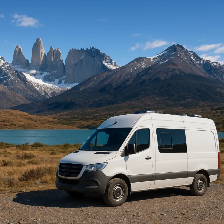
| Campervan | Integrated sleeping setup | Ferry rules, handling, limited availability | ✅ Great if properly equipped |
A 4WD does not make the road invincible. It can help with traction, but it cannot defeat a landslide, a closed ferry, or a driver entering a bend too quickly.
Rental companies, insurance, and cross-border requirements
Compare established operators such as:
Always ask in writing:
- Is travel on the Caretera Austral permitted?
- Is ripio driving covered?
- Is a second spare tire available?
- Is roadside assistance valid in remote Aysén?
- Can the vehicle enter Argentina?
- What border authorization documents are supplied?
- Are ferry crossings covered?
- What happens after a puncture or windshield damage?
- Are there restrictions on unsealed roads?
- Is there a mileage limit?
The paperwork for Argentina can be the hardest part. Arrange authorization before departure, not at the border while a queue of trucks grows behind you.
How we managed to find a car and driver
For travelers who do not want to drive rough gravel or manage every ferry connection, a private driver or local guide can be worthwhile. Operators such as EcoChile Travel arrange combinations of:
- Transport.
- Accommodation.
- Ferries.
- Hiking guides.
- Outdoor equipment.
- Cross-border logistics.
This costs more than self-driving, but it can reduce stress and improve local access. A driver also lets everyone look out the window when the mountains become ridiculous.
Driving the Caretera Austral: gravel roads, potholes, and one-lane bridges
Use this process on every rough section:
- Reduce speed before the surface deteriorates.
- Keep both hands on the wheel.
- Leave generous space from vehicles ahead.
- Avoid sudden braking on loose gravel.
- Slow dramatically before blind corners.
- Expect cyclists, hikers, livestock, and hitchikers.
- Pull completely off the road before stopping.
- Check tires at every fuel stop.
- Let faster local traffic pass.
- Stop driving if visibility or wind becomes unsafe.
A common mistake is staring at the pothole you want to avoid and then driving directly into it. Look toward the safe line instead. Patagonia rewards calm steering, not heroic improvisation.
Know Before You Go: Planning Essentials
The Caretera Austral is best planned in layers:
- Layer 1: route and season.
- Layer 2: vehicle and ferries.
- Layer 3: fuel, food, accommodation, and parks.
- Layer 4: backup plans for weather and mechanical problems.
If one layer changes, the others need room to move.
Best time to drive the Caretera Austral
The most accessible period is generally December through March, the Southern Hemisphere’s summer. Days are long, outdoor activities are more available, and ferry operations are usually more frequent.
| Season | Advantages | Challenges |
|---|---|---|
| December–January | Long daylight, active tourism season | More visitors, advance bookings needed |
| February–March | Often calmer, good hiking conditions | Weather still variable, some services wind down |
| April–May | Autumn colors, fewer travelers | Shorter days, closures begin |
| June–August | Snowy landscapes, quieter roads | Ferry and park restrictions, difficult driving |
| September–November | Spring scenery, returning daylight | Unpredictable weather, limited services |
The exact “best month” depends on your priorities. For hiking and broad access, choose January to March. For solitude and autumn color, consider late March or April, but accept greater uncertainty.
Check official park notices through CONAF and current weather through MeteoChile.
How many days you need for the full route
Use these planning ranges:
| Trip length | What it allows |
|---|---|
| 10–14 days | One region, such as Pumalín and Queulat or Coyhaique to Cochrane |
| 21 days | Major highlights with careful scheduling |
| 28 days | Full route with hikes and some flexibility |
| 35+ days | Detours, rest days, weather delays, and slower travel |
If you have only two weeks, do not force Puerto Mont to Villa O’Higgins. Choose a section and enjoy it properly. The route is not a loyalty program; you do not receive extra points for exhaustion.
One-way, out-and-back, or point-to-point itineraries
One-way route
Best for:
- Maximum scenery.
- Combining Chile with Argentina.
- Travelers flying home from Balmaceda, El Calafate, or another regional airport.
Drawback: one-way rental fees and border logistics can be complicated.
Out-and-back route
Best for:
- Keeping the rental simple.
- Avoiding cross-border paperwork.
- Travelers with flexible time.
Drawback: you repeat long stretches.
Point-to-point with public transport
Possible, but slower and less flexible. Buses connect some towns, while ferries and local transfers can fill gaps. Check Bus-Sur and local operators before relying on this approach.
Border crossings between Chile and Argentina
Popular crossings include:
- Paso Futaleufú.
- Paso Coyhaique/Huemules.
- Paso Chile Chico–Los Antiguos.
- Paso Roballos.
- The Villa O’Higgins–El Chaltén connection, which involves boat and trekking logistics rather than a simple drive.
Requirements can include:
- Passport validity.
- Vehicle authorization.
- Rental-company permission.
- Insurance valid in Argentina.
- Customs declarations.
- Food and agricultural restrictions.
Consult Chile Aduanas and Argentina’s migration authority before departure.
Ferries, timetables, reservations, and road closures
Ferries are not scenic extras; they are part of the road. Verify schedules through Transporte Público de Chile and the operating ferry company.
Major ferry planning principles
- Book the Hornopirén–Caleta Gonzalo connection early.
- Confirm vehicle dimensions and passenger details.
- Arrive well before departure.
- Keep food, water, and warm layers accessible in the vehicle.
- Do not pack all essentials in the luggage compartment if you cannot reach it during transit.
- Recheck schedules the day before travel.
Some crossings operate frequently and may not require reservations; others run only a few times daily. Road construction can also create temporary ferry routes or long detours.
Fuel, cash, ATMs, and mobile coverage
Refuel whenever the tank reaches approximately half full if a reliable station appears. Common strategic stops include:
- Puerto Mont.
- Chaitén.
- Futaleufú.
- La Junta.
- Coyhaique.
- Puerto Río Tranquilo.
- Cochrane.
Carry:
- Chilean pesos.
- At least two bank cards.
- A small emergency cash reserve.
- Offline fuel-stop notes.
- A physical or downloaded road map.
Mobile coverage is strongest in larger towns and weakest in valleys, parks, and remote crossings. Download:
User-generated apps are helpful for recent campsite and repair notes, but verify dates. A comment from last summer may be useless after a bridge closure.
Weather, wind, rain, and seasonal road conditions
The route crosses multiple microclimates. You may leave Coyhaique under blue sky and reach a sideways rainstorm before lunch.
Plan for:
- Heavy rain.
- Suden cold.
- Strong crosswinds.
- Low cloud.
- Snow at elevation.
- Sunburn under cloud.
- Mud and standing water.
- Rapid temperature changes.
The Dirección Meteorológica de Chile is more useful than trusting a single weather app forecast for an entire region.
Travel insurance, safety, and emergency contacts
Choose insurance that covers:
- Hiking at your planned elevation.
- Glacier activities.
- Whitewater rafting.
- Vehicle evacuation or roadside assistance.
- Medical evacuation.
- Trip interruption due to transport disruption.
Useful emergency numbers in Chile include:
- 131: ambulance.
- 132: firefighters.
- 133: police.
- 136: mountain rescue in relevant areas.
The U.S. Embassy in Chile and your own country’s foreign office provide current travel advisories, but local park rangers and accommodation hosts often know the immediate reality better.
What to Pack for Patagonia
Packing for the Caretera Austral is not about bringing everything. It is about bringing the items that prevent small problems becoming expensive disasters.
Caretera Austral camping gear checklist
| Category | Recommended equipment | Why it matters |
|---|---|---|
| Shelter | Four-season or sturdy three-season tent | Wind and rain are serious |
| Sleeping | Warm sleeping bag, insulated pad, pillow | Cold ground steals heat quickly |
| Cooking | Two-burner stove, fuel, lighter backup | Restaurants are not everywhere |
| Water | Durable bottles or bladder, filter | Long stretches lack services |
| Lighting | Rechargeable headlamp and spare battery | Darkness arrives at inconvenient moments |
| Navigation | Offline maps, paper backup, compass | Coverage disappears |
| Repairs | Tire plug kit, pump, duct tape, zip ties | Small fixes can save a day |
| Hygiene | Biodegradable soap, toilet paper, trowel | Facilities vary wildly |
| Weather | Waterproof shell, dry bags, pack cover | Rain finds every weakness |
| Power | Power bank, vehicle USB charger | Useful between towns |
| Comfort | Camp chair, earplugs, eye mask | Wind and campsite noise are real |
Brands such as MSR, Sea to Summit, Therm-a-Rest, Black Diamond, and Osprey make reliable outdoor equipment. For this route, prioritize durability and repairability over ultralight braging rights.
Clothing for four seasons in one day
Pack a layering system:
- Moisture-wicking base layer.
- Warm fleece or synthetic mid-layer.
- Insulated jacket.
- Waterproof, windproof shell.
- Quick-drying hiking trousers.
- Warm hat and gloves.
- Sun hat and sunglasses.
- Several pairs of wool or synthetic socks.
A cotton hoodie is pleasant until it gets wet. Then it becomes a cold towel.
Secure sunglasses with a retainer such as Chums or a similar strap. Strong wind can turn a pair of glasses into a small but surprisingly expensive kite.
Food, water, cooking equipment, and road snacks
Buy substantial supplies in Puerto Mont or Coyhaique. Carry:
- Oats.
- Pasta or rice.
- Lentils.
- Tuna or shelf-stable protein.
- Crackers.
- Nuts.
- Chocolate.
- Fruit that travels well.
- Instant coffee or tea.
- Electrolyte tablets.
- Reusable water containers.
A cooler helps, but ice can be difficult to find. A quality YETI cooler is excellent but bulky; a soft cooler such as RTIC is easier to pack.
👉 CHECK PRICE on:
- YETI Coolers: Amazon | YETI Official Website
- MSR Camping Stoves: Amazon | MSR Official Website
- Sea to Summit Dry Bags: Amazon | Sea to Summit Official Website
Navigation apps, offline maps, and photography equipment
Download maps before leaving reliable Wi-Fi. Save:
- Campsites.
- Fuel stations.
- Mechanics.
- Ferries.
- Border posts.
- Park entrances.
- Accommodation addresses.
A compact camera or weather-sealed phone is ideal. Use dry bags and lens cloths. The landscape is photogenic; the weather is less cooperative.
Camping, Lodges, Hostels, and Accommodation
Camping lets you experience the route’s silence, but silence is not guaranteed. Wind can make a tent sound like a helicopter audition.
Wild camping rules and Leave-No-Trace practices
Wild camping may be possible in some areas, but land can be private, protected, or environmentally sensitive. Follow Leave No Trace principles and:
- Ask permission on private land.
- Camp on durable surfaces.
- Stay away from river edges vulnerable to flooding.
- Keep fires out of fragile vegetation.
- Pack out toilet paper and waste.
- Avoid washing with soap in rivers.
- Never leave food scraps.
- Do not block roads or access tracks.
Use formal campsites in national parks whenever available.
Best campsites along the Caretera Austral
Campsite conditions vary. Expect anything from a maintained campground with hot showers to a flat patch of ground beside a river.
Notable areas include:
- Pumalín campsites near Chaitén.
- Camping Ventisquero.
- Campsites around Futaleufú.
- Queulat National Park.
- Cerro Castillo and Villa Cerro Castillo.
- Parque Patagonia.
- Río Baker camping areas.
- Sites near Caleta Tortel and Cochrane.
Read recent user reports on iOverlander and confirm park rules with CONAF.
Booking accommodation in peak season
Reserve ahead for:
- December through February.
- National park campsites.
- Ferry-linked nights.
- Puerto Mont.
- Coyhaique.
- Puerto Río Tranquilo.
- Guided glacier excursions.
- Futaleufú rafting trips.
In smaller towns, guesthouses and family-run hospedajes may have limited online presence. Ask locally, but do not assume every vacancy is legitimate or suitable for late-night arrival.
Camping comfort: showers, laundry, Wi-Fi, and power
Prepare for limited amenities. Experienced travelers have reported only a handful of hot showers during a multi-week camping trip. That sounds dramatic until you discover how quickly a cold river bath becomes a personality test.
Bring:
- Wet wipes.
- Quick-dry towel.
- Biodegradable soap.
- Laundry line.
- Small sink or dry bag for washing.
- Power bank.
- Earplugs.
- Eye mask.
Coyhaique is the best place for laundry, showers, repairs, and a proper meal. Treat it as a reset button, not an optional detour.
Food, Fuel Stops, and Supplies Along the Route
Remote-road appetite is real. After several hours of gravel, a simple empanada can taste like a Michelin-stared revelation.
Strategic resupply towns
| Town | Best for | Advice |
|---|---|---|
| Puerto Mont | Full grocery and gear stock-up | Buy fuel, cash, SIM, camping food |
| Chaitén | Fuel, groceries, mechanics | Recheck vehicle before continuing |
| Futaleufú | Fuel, restaurants, adventure activities | Good place for rafting and outdoor gear |
| La Junta | Basic supplies and accommodation | Do not expect a large supermarket |
| Coyhaique | Major resupply, laundry, repairs | Stock up for the southern sections |
| Puerto Río Tranquilo | Fuel, Marble Caves, glacier trips | Fill up before heading south |
| Cochrane | Fuel, groceries, repairs | Prepare for remote roads beyond town |
| Villa O’Higgins | Final southern supplies | Limited selection and seasonal services |
What to ask at a fuel station
Before leaving, ask:
- Is the next station open?
- Is the road passable?
- Is the next fuel station definitely operating?
- Are there construction delays?
- Is cash required?
- Is the road to the detour open?
Local information is often more current than an app, particularly after storms or landslides.
Eating along the Caretera Austral
Expect:
- Empanadas.
- Hearty soups.
- Asado.
- Sandwiches.
- Fresh bread.
- Local berries.
- Simple seafood in coastal areas.
- Craft beer in towns such as Futaleufú and Coyhaique.
Small restaurants may open only during limited hours. Carry dinner ingredients even when you expect to eat out.
Best Things to Do and See on the Caretera Austral
The route offers enough activities to fill months. The trick is choosing experiences that match your weather window and fitness level.
National parks and protected landscapes
Prioritize:
- Pumalín Douglas Tompkins National Park.
- Queulat National Park.
- Cerro Castillo National Park.
- Patagonia National Park.
- Laguna San Rafael National Park.
- The protected landscapes around Villa O’Higgins.
Park conditions, opening hours, and trail access can change. Check directly before setting out.
Hiking, kayaking, rafting, and glacier excursions
Hiking
Best-known options include:
- Volcán Chaitén.
- Cascadas Escondidas.
- Ventisquero Yelcho.
- Queulat glacier viewpoints.
- Cerro Castillo Laguna.
- Avilés Trail in Parque Patagonia.
- Lagunas Altas.
- Trails near Villa O’Higgins.
Whitewater rafting
The Río Futaleufú is internationally known for powerful rapids and clear mountain water. Beginners should choose a reputable operator, while experienced paddlers should still respect changing river conditions.
Book with established providers such as Futaleufú Expediciones or Patagonia Elements, and confirm current safety procedures.
Glacier experiences
Near Puerto Río Tranquilo, operators offer:
- Exploradores Glacier viewpoints.
- Full-day glacier trekking.
- Crampon excursions.
- Ice-cave exploration when conditions permit.
Glacier access is weather-dependent and physically demanding. Use a licensed guide and never walk onto glacial ice independently.
Wildlife watching and responsible nature travel
Possible sightings include:
- Condors.
- Foxes.
- Guanacos.
- Huemul deer.
- Dolphins near coastal areas.
- Waterfowl and forest birds.
- Andean wildlife around protected parks.
Keep your distance, do not feed animals, and use a long lens rather than your feet. Chile’s National Biodiversity and Protected Areas Service provides current conservation information.
A Detailed 21-Day Caretera Austral Road Trip Itinerary
This itinerary follows the broad structure of a classic three-week journey, with adjustments for reality. It assumes summer travel, a capable rental vehicle, and a willingness to change plans when ferries or weather intervene.
1. Puerto Mont to Hornopirén: ferry connections and first views
Driving and ferry focus: Puerto Mont, Caleta La Arena, Puelche, Hornopirén.
Start with supplies, fuel, cash, and offline downloads. The first ferry from La Arena to Puelche is generally simpler than the longer ferry system farther south, but confirm current operations.
Possible additions:
- Puerto Varas.
- Lake Llanquihue.
- Petrohué Waterfalls.
- Volcán Osorno viewpoints.
Allow time for the drive to Hornopirén rather than treating it as a mere transfer. The fjord scenery begins early, and the first day sets the pace for the entire trip.
2. Hornopirén to Cascadas Escondidas in Pumalín National Park
Reserve the ferry from Hornopirén toward Caleta Gonzalo well ahead. The journey can involve multiple ferry segments and a short road transfer.
At Pumalín:
- Walk to Cascadas Escondidas.
- Set up camp before dark.
- Keep rain gear accessible.
- Protect food from moisture.
The rain forest here is lush for a reason. Waterproof footwear is not optional decoration.
3. Cascadas Escondidas to Camping Ventisquero in Pumalín
Continue through Pumalín and consider a hike near Chaitén if conditions allow. The landscape changes quickly from rainforest to volcanic terrain.
Campground advice:
- Arrive early in peak season.
- Keep tent doors closed during rain.
- Dry wet clothing before nighttime temperatures fall.
- Ask campground staff about trail closures.
4. A second night at Camping Ventisquero
Use a second night to avoid turning every day into a relocation exercise. Options may include:
- Volcán Chaitén hike.
- Ventisquero Yelcho.
- Short forest trails.
- A recovery day after ferry travel.
Volcán Chaitén is steep and exposed in places. Start early, carry water, and avoid the trail during high wind or poor visibility.
5. Camping Ventisquero to Futaleufú
This is a rewarding transition from coastal rainforest into mountain valleys. Refuel in Chaitén and check the route before continuing.
Futaleufú deserves more than a sleep-and-leave stop. Consider:
- Rafting.
- Kayaking.
- Horse riding.
- Viewpoint hikes.
- Lakeside camping.
- Local restaurants and breweries.
The river can close for safety reasons. A closed rafting day is disappointing, but a swimming rescue is worse.
6. Futaleufú tree-house camp to stone-house camp
Adventure lodges and private camps around Futaleufú can turn this into one of the trip’s most memorable sections. Experiences may include:
- Wood-fired hot tubs.
- Platform camps.
- Guided hikes.
- Tyrolean traverses.
- River viewpoints.
- Asado dinners.
Book in advance if you want specialist accommodation. For independent travelers, the surrounding valley still offers excellent hikes and campsites.
7. Futaleufú to La Junta
Allow extra time for bends, gravel, and photo stops. La Junta is useful for:
- Fuel.
- Basic groceries.
- A hot shower.
- A simple meal.
- Local route information.
The road can look deceptively empty. Keep your headlights on and expect cyclists, pedestrians, and livestock.
8. La Junta to Raúl Marín Balmaceda
This coastal detour adds time but rewards travelers seeking quiet landscapes. Depending on conditions, look for:
- Dolphin sightings.
- Estuary scenery.
- Forest trails.
- Coastal beaches.
- Local seafood.
The area is vulnerable to weather and road changes, so do not attach a rigid ferry or accommodation deadline to this day.
9. Raúl Marín Balmaceda to Queulat National Park
Return toward the main route and continue to Queulat. The headline attraction is Ventisquero Colgante, the Hanging Glacier.
Plan for:
- A marked viewpoint hike.
- Mudy conditions after rain.
- Limited visibility under cloud.
- Park entry procedures.
- Possible camping inside or near the park.
A longer viewpoint is usually worth the extra effort if open. Glaciers are dramatic even when clouds decide to edit the skyline.
10. Queulat National Park to Puerto Cisnes
Puerto Cisnes offers a quieter coastal pause. Use it for:
- A seafood meal.
- Fuel or basic supplies.
- A relaxed evening.
- Local walks.
- Weather assessment before heading inland.
If camping outside town, choose a legal and respectful site. Do not assume an empty beach is automatically public land.
11. Coyhaique: markets, restaurants, and road-trip resupply
Coyhaique is the logistical heart of the route. Restock:
- Fuel.
- Food.
- Gas canisters.
- Batteries.
- Outdoor clothing.
- Vehicle supplies.
- Laundry.
The city has more accommodation and restaurant choice than most stops on the route. A local brewery or hearty burger can feel like civilization’s warmest embrace.
12. Coyhaique: rest day and Patagonian excursions
Take a genuine rest day. Use it to:
- Check tire pressure.
- Inspect the spare.
- Wash clothing.
- Back up photographs.
- Download maps.
- Recheck ferries and park notices.
- Rebuild your food supply.
Skipping this pause often creates trouble later. The southern section is more remote, so leave Coyhaique organized rather than optimistic.
13. Coyhaique to Cerro Castillo
Cerro Castillo is one of the route’s defining landscapes. The peaks rise like a stone fortress above the valley.
Options include:
- Laguna Cerro Castillo day hike.
- Multi-day circuit.
- Shorter valley walks.
- Viewpoints along the highway.
- Camping near Villa Cerro Castillo.
The full hike is demanding, with steep and potentially loose sections. Wind can be intense near the exposed upper terrain.
14. Cerro Castillo to Río Ibáñez
Continue toward Lago General Carrera and the Río Ibáñez area. This is a beautiful section for:
- Mountain photography.
- Horse riding.
- Short hikes.
- Rural guesthouses.
- Lake viewpoints.
Ask permission before camping on private land. “There is no fence” is not the same as “welcome.”
15. A flexible Coyhaique buffer day
A return or buffer day in Coyhaique may feel inefficient on paper. In practice, it can rescue the itinerary after:
- A delayed ferry.
- A tire problem.
- A storm.
- A missed hike.
- A day lost to construction.
This is one of the best places to solve problems before the route becomes significantly more remote.
16. Coyhaique to Puerto Río Tranquilo
The road toward Puerto Río Tranquilo delivers some of Patagonia’s most vivid color contrasts:
- Blue-green water.
- Pale rock.
- Dark forests.
- Snowy peaks.
- Wide skies.
Fill up before arriving if possible. Services in Puerto Río Tranquilo are limited and seasonal.
17. Puerto Río Tranquilo to Exploradores Glacier
Reserve glacier activities in advance when possible. Options may include:
- Marble Caves boat trip.
- Guided kayaking.
- Exploradores Glacier viewpoint.
- Full-day glacier trek.
Weather can close the lake port, so keep a backup day. The glacier experience is physically demanding and should be guided.
18. Exploradores Glacier to Cochrane
Continue south through broad valleys and along the spectacular Río Baker region.
Recommended stops:
- Río Baker and Río Nef confluence.
- Roadside viewpoints.
- Short river walks.
- Local cafés in Cochrane.
- Fuel and groceries before remote sections.
The water color can look digitally enhanced. It is not. Patagonia simply has an unfair advantage.
19. Cochrane to Caleta Tortel
Caleta Tortel is unlike most settlements in Chile. Wooden walkways replace ordinary streets, and the village spreads across a coastal landscape of water, forest, and timber.
Allow time to:
- Park at the designated area.
- Walk the boardwalks.
- Explore viewpoints.
- Carry water.
- Wear shoes with good grip.
Vehicles cannot continue deep into the village, which is part of its charm.
20. Exploring Parque Patagonia
Parque Patagonia rewards travelers who slow down. Popular hikes include:
- Avilés Trail.
- Lagunas Altas.
- Shorter valley walks.
- Wildlife-viewing routes.
The park sits near major conservation landscapes and the Argentine border. Check Parque Patagonia visitor information before arrival because access and services can be seasonal.
21. Parque Patagonia to El Chaltén, Argentina
This is an ambitious border day. Paso Roballos is remote, and the distance between services can be enormous.
Before leaving:
- Fuel completely.
- Carry food and water.
- Check border opening status.
- Confirm rental authorization.
- Download Argentina maps.
- Tell someone your plan.
- Avoid attempting the drive late in the day.
Once in Argentina, El Chaltén provides a dramatic continuation with Fitz Roy and Los Glaciares National Park. The Argentine National Parks Administration has official information.
Best Detours and Alternative Caretera Austral Itineraries
The route is already packed with highlights, but these detours can transform a good trip into an unforgettable one.
Villa O’Higgins and the southern terminus
Villa O’Higgins is the official southern end of the Caretera Austral. It is worth reaching if you have enough time, especially for:
- O’Higgins Glacier excursions.
- Remote hiking.
- Mountain scenery.
- The sense of arriving at the road’s true endpoint.
The connection toward El Chaltén may involve boats, border procedures, and trekking. It is not a simple drive-through crossing. Confirm seasonal operations through local operators before committing.
Marble Caves and Lago General Carrera
The Marble Caves near Puerto Río Tranquilo are best visited in calm weather. Boat tours can be canceled when wind makes the lake unsafe.
For the best experience:
- Book or confirm the tour locally.
- Ask whether the port is open.
- Bring a warm layer.
- Protect phones and cameras from spray.
- Keep a backup activity available.
Kayaking offers a lower, slower perspective but requires suitable weather and a qualified guide.
Futaleufú for whitewater adventures
Futaleufú is a destination in its own right. The river’s reputation attracts experienced paddlers, but beginners can also join guided sections.
Choose an operator that provides:
- Certified guides.
- Proper helmets and flotation devices.
- Safety briefing.
- Rescue procedures.
- Weather and river-level checks.
- Clear age and fitness requirements.
Adventure travelers can find more inspiration in our Adventure Travel category.
Pumalín Douglas Tompkins National Park
Pumalín’s appeal comes from scale and intimacy. You may encounter giant trees, waterfalls, mossy forest, and volcanic landscapes within a single day.
Stay longer if you enjoy:
- Rainforest hikes.
- Waterfalls.
- Camping.
- Birdwatching.
- Quiet forest trails.
Carry rain protection even under a clear morning sky. Pumalín does not apologize for being wet.
Queulat Hanging Glacier and Ventisquero Colgante
Queulat is one of the route’s essential stops. The glacier hangs above a forested valley, with meltwater cascading toward the valley floor.
Arrive early to:
- Beat peak visitor periods.
- Improve parking chances.
- Hike in cooler conditions.
- Allow time if the first viewpoint is clouded.
The glacier can be partly hidden, but the surrounding rainforest and waterfalls still make the stop worthwhile.
Common Caretera Austral Problems and How to Handle Them
A road trip here is not difficult because every day is dangerous. It is difficult because ordinary problems can take longer to solve.
Punctures, mechanical breakdowns, and spare tires
Before departure, inspect:
- Tire tread.
- Spare tire pressure.
- Jack compatibility.
- Wheel-lock key.
- Coolant.
- Oil.
- Windshield condition.
- Wiper blades.
- Battery terminals.
Carry:
- Tire inflator.
- Plug kit.
- Work gloves.
- Headlamp.
- Reflective vest.
- Basic tools.
- Duct tape.
- Cable ties.
If you break down:
- Move off the road.
- Turn on hazard lights.
- Put out warning triangles if supplied.
- Contact the rental company.
- Ask the nearest accommodation or fuel station for local assistance.
- Conserve battery power.
- Do not abandon the vehicle without clear instructions.
Missed ferries and delayed travel days
A missed ferry can affect the next two nights. Prevent cascading problems by:
- Booking critical crossings.
- Arriving early.
- Keeping confirmation details offline.
- Leaving a buffer after the ferry.
- Avoiding a nonrefundable hotel immediately after a long crossing.
If delays happen, prioritize safety and sleep over preserving the original plan.
Limited internet, changing plans, and offline communication
Download essential information before leaving town:
- Maps.
- Reservations.
- Emergency numbers.
- Ferry confirmations.
- Park information.
- Translation tools.
- Accommodation directions.
A satellite messenger such as Garmin inReach can be sensible for solo travelers, long hikes, and remote detours. It is not a substitute for judgment, but it can provide a communication link where phones cannot.
Wildlife, livestock, and roadside hazards
Slow down for:
- Horses.
- Sheep.
- Cattle.
- Dogs.
- Guanacos.
- Wildlife crossing unexpectedly.
- Cyclists and pedestrians.
At dawn and dusk, visibility is poorer and animals are more active. A beautiful empty road can still contain a cow around the next corner. Patagonia’s cows do not respect your itinerary.
Responsible travel in fragile Patagonian ecosystems
Avoid:
- Driving off-road.
- Collecting rocks or plants.
- Feeding wildlife.
- Lighting unauthorized fires.
- Leaving toilet paper.
- Flying drones near wildlife or restricted areas.
- Camping beside fragile wetlands.
- Entering closed trails.
Support local communities by using family-run accommodation, buying regional food, and hiring local guides.
Essential Caretera Austral Road Trip Tips
Driving etiquette on Chilean gravel roads
The safest driving rhythm is unhuried:
- Stay right.
- Use headlights.
- Slow before passing.
- Expect dust clouds.
- Give cyclists a wide berth.
- Avoid stopping on blind bends.
- Signal before pulling over.
- Let local drivers pass.
If a truck approaches, reduce speed early. Dust can eliminate visibility in seconds.
How to build rest days and weather buffers
For every five or six travel days, plan one flexible day. Use it for:
- Weather.
- Laundry.
- Repairs.
- A longer hike.
- A missed ferry.
- A spontaneous detour.
The trip becomes much more enjoyable when a storm is an inconvenience rather than a catastrophe.
Photography tips for mountains, glaciers, and roadside landscapes
Bring:
- Lens cloths.
- Dry bags.
- Extra batteries.
- Polarizing filter if using a camera.
- Small tripod.
- Phone power bank.
- Backup storage.
Shoot early and late when light is softer. In windy weather, brace the camera against a stable surface. For glaciers, include people or trees for scale.
How to travel more sustainably
Choose:
- Shared ferries and local transport.
- Refillable water bottles.
- Reusable food containers.
- Small, locally owned accommodations.
- Licensed guides.
- Existing campsites.
- Low-impact hiking practices.
The Chile Travel sustainability guidance and Leave No Trace provide useful standards.
Caretera Austral Frequently Asked Questions
What safety precautions should I take when driving the Caretera Austral?
Drive slowly on gravel, carry a full-size spare, check the weather and road conditions daily, and avoid driving after dark. Tell your accommodation host about long or remote travel days.
What should I do if my car breaks down?
Move completely off the road, use hazard lights and warning equipment, contact the rental company, and conserve phone battery. Do not attempt a risky repair beside active traffic.
How can I prepare for the weather conditions on the Caretera Austral?
Pack waterproof and windproof outer layers, warm insulation, quick-dry clothing, and dry bags. Check MeteoChile before leaving each town and allow days for storms.
Can weather cancel ferries and activities?
Yes. Wind and rough water cancel ferries, Marble Caves tours, glacier trips, and rafting. Keep backup plans and never pressure an operator to go out in unsafe conditions.
What are the essential packing tips for a Caretera Austral adventure?
Bring layered clothing, waterproof footwear, a warm sleeping system, offline maps, power banks, water containers, food, first-aid supplies, tire-repair equipment, cash, and personal medication.
Do I need camping gear?
Not necessarily. You can combine guesthouses, hostels, and lodges with occasional camping. However, camping gear provides valuable flexibility when accommodation is full or weather disrupts your plan.
Are there any must-see stops along the Caretera Austral?
Yes. Our essential shortlist includes:
- Pumalín National Park.
- Futaleufú.
- Queulat Hanging Glacier.
- Cerro Castillo.
- Marble Caves.
- Exploradores Glacier.
- Río Baker.
- Caleta Tortel.
- Parque Patagonia.
- Villa O’Higgins.
If time is limited, prioritize the region matching your interests rather than attempting the full route.
What type of vehicle is recommended for the Caretera Austral road trip?
Choose a high-clearance SUV, pickup, or 4WD with a full-size spare and permission for gravel roads. A 4WD is helpful for remote detours but is not a magic shield against poor weather or road closures.
Can a 2WD vehicle complete the route?
Some travelers manage sections in 2WD vehicles during favorable conditions, especially where the road is paved or well graded. For the complete route with camping equipment, a higher-clearance vehicle is the safer choice.
How many days do you need to complete the Caretera Austral route?
Plan at least 21 days for major highlights and 28–35 days for a relaxed full-route trip with hikes, detours, and weather buffers.
Is 10 days enough?
Ten days is better spent one region. Consider Puerto Mont to Chaitén, or Coyhaique to Cochrane, rather than attempting the entire highway.
What is the best time of year for a Caretera Austral road trip?
For the greatest access, choose December through March. January and February generally offer long daylight and the broadest tourism services, while March can bring fewer visitors.
Can I drive the route in winter?
Yes, in selected sections and with careful preparation, but snow, short daylight, ferry changes, and seasonal closures make winter substantially more demanding.
What are the best stops and attractions along the Caretera Austral?
The strongest combination is:
- Volcán Chaitén.
- Cascadas Escondidas.
- Futaleufú rafting.
- Queulat National Park.
- Cerro Castillo Laguna.
- Marble Caves.
- Exploradores Glacier.
- Río Baker.
- Caleta Tortel.
- Avilés Trail in Parque Patagonia.
How difficult is driving the Caretera Austral in Chile?
The route is manageable for confident drivers but demanding because of gravel, potholes, wind, ferries, construction, and remoteness. The physical driving is less difficult than the planning discipline.
What makes it challenging?
The biggest issues are not constant extreme terrain. They are delayed ferries, changing weather, long distances between services, limited coverage, and the consequences of small mistakes.
Where can you find fuel, food, and accommodation along the Caretera Austral?
Major resupply points include Puerto Mont, Chaitén, Futaleufú, Coyhaique, Puerto Río Tranquilo, Cochrane, and Villa O’Higgins. Services become smaller and less predictable farther south.
Should I carry extra fuel?
Yes. Refuel whenever possible and consider a compliant auxiliary fuel container for remote sections. Follow transport and safety rules, and never store fuel inside the passenger compartment.
What should you pack for an unforgettable Caretera Austral adventure?
Pack for rain, wind, cold, and limited services:
- Waterproof shell.
- Warm layers.
- Durable footwear.
- Offline maps.
- Power bank.
- First-aid kit.
- Tire-repair equipment.
- Water filter or purification method.
- High-energy food.
- Cash.
- Dry bags.
- Headlamp.
- Emergency communication for remote travel.
The question we raised at the beginning now has its answer: yes, you can drive the Caretera Austral in three weeks, but the route becomes significantly better when you give it four or five. The best itinerary is not the one with the most pins on a map. It is the one that leaves room for a storm, a perfect viewpoint, a long lunch, and the occasional roadside llama with poor timing.
Caretera Austral Road Trip Conclusions
The Caretera Austral is a demanding road trip, but not because it requires superhero driving. It asks for preparation, patience, and a willingness to let Patagonia rearrange your schedule.
Our confident recommendations
✅ Spend at least three weeks on the full route.
✅ Choose a high-clearance vehicle with a full-size spare.
✅ Reserve major ferries and popular summer accommodation.
✅ Use Coyhaique for repairs, laundry, fuel, and food.
✅ Prioritize Pumalín, Futaleufú, Queulat, Cerro Castillo, Marble Caves, Caleta Tortel, and Parque Patagonia.
✅ Keep two to four flexible days.
✅ Download everything before leaving a connected town.
✅ Support local businesses and protect the landscapes that make the route special.
❌ Do not plan every hour.
❌ Do not drive fast on ripio.
❌ Do not assume a remote border crossing is open.
❌ Do not leave without checking your rental contract.
❌ Do not treat a closed trail or canceled ferry as a personal insult. Patagonia is not being difficult; it is being Patagonia.
The road is long, the weather is mody, and the logistics occasionally resemble a group project nobody organized. Yet the reward is enormous: fjords at sunrise, glaciers above rainforest, rivers the color of melted turquoise, and small communities that make remote travel feel unexpectedly warm.
For more ideas, continue with our Destinations, Adventure Travel, and Cultural Experiences guides.
Recommended Links
👉 CHECK PRICE on:
- Garmin inReach Satellite Communicators: Amazon | Garmin Official Website
- YETI Coolers: Amazon | YETI Official Website
- MSR Camping Stoves: Amazon | MSR Official Website
- Therm-a-Rest Sleeping Pads: Amazon | Therm-a-Rest Official Website
- Black Diamond Headlamps: Amazon | Black Diamond Official Website
- Sea to Summit Dry Bags: Amazon | Sea to Summit Official Website
- Osprey Hiking Backpacks: Amazon | Osprey Official Website
- Chile Travel Guides: Amazon
- Patagonia Hiking Books: Amazon
- Moon Chile Guide by Steph Dyson: Amazon
Plan the trip with:
- Chile Travel Official Website
- CONAF National Parks
- MeteoChile Weather Service
- iOverlander
- Organic Maps
- EcoChile Travel
- Rentalcars.com Chile
Reference Links
- Chile Travel: Official Tourism Information
- Chile National Forest Corporation, CONAF
- Chile Ministry of Public Works
- Chile Meteorological Directorate, MeteoChile
- Chile Customs Service
- Chile Sustainable Tourism Guidance
- Parque Patagonia Official Website
- Tompkins Conservation
- Leave No Trace Principles
- Argentina National Parks Administration
- Argentina Migration Authority
- Transporte Público de Chile
- Worldly Adventurer: The Caretera Austral, The Ultimate 2026 Travel Guide
- Traveling Jackie: 21 Days on the Caretera Austral
- In4Adventure: The World’s Most Badass Road Trip
- Futaleufú Adventure Operators
- Patagonia Elements
- Europcar Chile
- Avis Chile
- Hertz Chile
- Chile Car Rentals